NATIONAL LANDSCAPE DAY – 14th MARCH THE ONLINE INITIATIVES OF THE ARCHAEOLOGICAL PARK
The landscape of Pompeii, from depictions in wall paintings and the story of the eruption and consequent transformations, to the complex work of maintaining the green areasof today
On the 14th March we celebrate National Landscape Day, an initiative launched by the Ministry of Culture to promote landscape resources through activities aimed at raising awareness, education and understanding of the landscape, and which is this year by necessity being held online.
To mark the occasion, the Archaeological Park of Pompeii has published several videos on its social media channels and institutional websites, which chart the story of the Pompeian landscape, from the transformations it underwent following the eruption, to the complex maintenance requirements of the extensive green areas currently included within the archaeological area, up to the redevelopment, reconstruction and valorisation projects of the historic gardens, which constituted a core element of the Roman domus. This is accompanied by a series of photographs illustrating the most beautiful landscape scenes which characterise the paintings in many dwellings.
From the Insula of the Chaste Lovers, where works are currently ongoing to stabilise the excavation fronts and refurbish the roofing, the Park’s vulcanologist and geologist will illustrate the stratigraphy of the eruption of AD 79, which was revealed in particular clarity during these works in a section close to one of the rooms where interventions are currently being conducted, in order to recount the phases and dynamics of the tragic event which buried Pompeii, as well as the changes which consequently took place in the landscape and geology of the area. Furthermore, the layers which form the subsoil of the city will be revealed and illustrated for the first time: layers which tell an ancient story of prehistoric inhabitation, volcanic eruptions, natural resources and changes in the landscape.
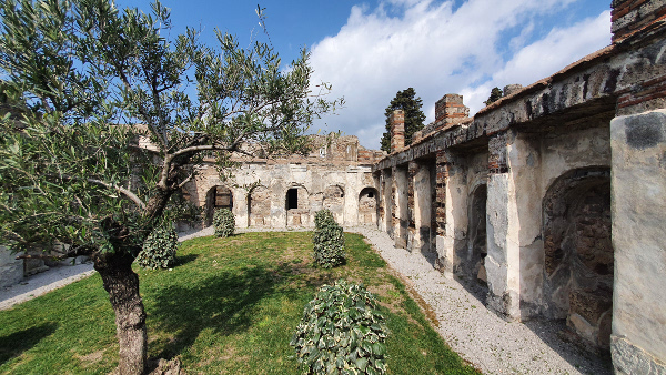
Starting with the garden of the House of the Anchor and Via dei Sepolcri, the complex multidisciplinary work which forms the basis of the management, conservation and renewal of the vast agronomic and landscape heritage of the Archaeological Park of Pompeii will be illustrated.
An additional series of images will highlight several landscape scenes in Pompeian painting: beginning with the recently restored House of the Ceii, and a comparison with the paintings in the House of Menander and the House of the Ephebe. The landscape paintings served to create optical illusions to expand the apparent dimensions of the areas, as in a sort of trompe-l’oeil, and often developed just like scenery, not unlike that used in theatres for the staging of tragedies. The landscape served as the background to depictions of mythological figures or human activities which are portrayed on the walls as if they were part of a theatrical animation which in particular accompanied social occasions, and helped to brighten the everyday view.
Finally, for Landscape Day, the Park will be showing the video images of the protohistoric site at Longola di Poggiomarino, in the upper Sarno valley, roughly 10 km east of Pompeii. The site, which comes under the jurisdiction of the Archaeological Park of Pompeii, is part of the Archaeological Natural Park of Longola, which is managed by the Comune of Poggiomarino. The wetland site is a perifluvial settlement, inhabited from the Middle Bronze Age until the 6th century BC. The aquatic nature of the village characterised life there throughout the phases of its history, and has resulted in the preservation of numerous perishable materials that constitute an exceptional archaeological record and which contribute towards making Poggiomarino a unique site of its kind in southern Italy. The site fills a significant gap in our understanding of the population of the Sarno Valley, which so far has primarily been documented by funerary contexts, and therefore contributes significantly to the reconstruction of the settlement dynamics at play in the times before the birth of Pompeii.
Here we are in the House of the Anchor, and this is one of the reimagined gardens in which we are now conducting maintenance works, and for me it is a good example of the dialogue that has been achieved, this multidisciplinary element that we have always striven for in the challenging matter of managing the green areas of Pompeii. Pompeii is a park of around 100 hectares which tourists are often not fully aware of, since they know only the gardens of the most famous Domus, but the park in fact has an entire extra moenia zone, that is outside the walls, which incorporates areas of great interest and also agricultural areas. In this particular case we are in the garden of the House of the Anchor, we are in Regio VI. It is a garden developed from historical, archaeological and archaeobotanical data, and indeed the management of the garden, the planting of the ivy and the treatment of the plants derives from an interpretation of the wall paintings of how the ancients could have managed these gardens, as well as from the archaeobotanical data of the pollens. It is an enclosed garden which also poses various maintenance problems, and in fact we can see how we are currently intervening on the turf as well as on the pruning of the plants, taking advantage of the opportunity the pandemic provides, when the site is not being visited by tourists, to conduct interventions aimed at regenerating the lawn. The work we are doing began in the 1980s, when significant efforts to reclaim the external area of Pompeii were made outside the wall circuit in order to eliminate the weeds and particularly the ailanthus colonisation, this tree which destroys everything, thus saving cultural heritage.We are in the extra moenia area of Pompeii, the area outside the ancient city.The ancient city, as we all know, covers an area of almost 60 hectares, but the entire Archaeological Park of Pompeii, a natural park, extends over 100 hectares, so the area beyond the walls and the path that goes through it is spread over an enormous area, which represents a formidable challenge for maintenance and management, as well as a challenge for planning the management of the green areas. Whilst stabilisation works have proceeded on the site in recent years, these areas have experienced maintenance issues linked to the continued passage of construction vehicles and equipment, so now is precisely the period in which restoration and renovation is able to take place, because this will become a new area accessible to visitors and tourists who will not only be able to visit the archaeological site, but will also be able to enjoy a naturalistic visit in this extraordinary landscape, unique in the world because it connects to the Vesuvian territory of the Vesuvius park. We have had major problems with the tall trees, particularly the pines, because they are afflicted by parasites which cause their rapid senescence and therefore the need for felling, so then the great challenge will be to quickly reconstruct new arboreal heritage. Accordingly, programs are being carried out for the afforestation of the Archaeological Park including the replacement of plants which are now dead but which perhaps belong to species not in line with the philological research carried out over the years, and also from a botanical and archaeobotanical point of view, and which are therefore not entirely coherent with the heritage in question, the so-called Pompeian flora. This lost heritage will be replaced with new trees which are more consistent with the philological botanical choices.
Today we are in one of the alleys of the Insula of the Chaste Lovers, in Regio IX of the archaeological site of Pompeii, and behind me we have the typical stratigraphic sequence of deposits from the eruption of AD 79 in the Archaeological Park of Pompeii. The eruption of AD 79 was one of the largest and most violent in the history of Vesuvius, and over the course of roughly 30 hours, about 4 cubic kilometres of volcanic materials, or more specifically ash and lapilli, were discharged. Behind me we can see the typical stratigraphy of the eruption. The stratigraphy is essentially composed of two principal units: the first unit is formed by the famous pumice of Pompeii, lapilli which fell from the eruptive column and which exhibit a peculiarity in that they show a vertical variation in colour, from white at the base to grey in the upper part - this colour change is due to a variation in the chemical composition of the magma during the eruption. These lapilli resulted from the initial phase of the eruption, when an eruptive column probably as high as 30km formed above the crater of the volcano, from which the lapilli fell into the atmosphere and settled primarily in the area south east of the volcano, thereby burying Pompeii under a blanket of pumice almost three metres thick. The upper part of the sequence on the other hand is formed by ash, ash stratified by a pyroclastic flow depositional mechanism. Pyroclastic flows are high temperature mixtures of gas, ash and lapilli which move down the flanks of the volcano under the influence of gravity. Here is the upper part of the sequence, that is the part of stratified ash which represents the sediments deposited by the multiple pyroclastic flows which struck Pompeii during the second eruptive phase. Of these pyroclastic flows, the second to reach Pompeii was particularly violent and energetic. It was dense, turbulent, extraordinarily strong, and so energetic that it was capable of knocking down walls located transverse to the direction of the flow. This flow was so violent that it almost entirely buried the structures of Pompeii, and resulted in many fatalities, some of whom it has been possible to make a plaster cast of, precisely because the bodies decomposed inside the ash, leaving behind a negative void which preserved the shape of the body. After this extremely violent pyroclastic flow, Pompei was reduced to a wasteland, where the pyroclastic flow had sown death and destruction, and the subsequent pyroclastic flows during the second day of the eruption simply contributed further to the dismantling of the city of Pompeii, which had already been almost entirely buried, with a further blanket of ash, which definitively buried Pompeii under at least seven metres of ash and lapilli.
Here we are in the west alley of the Insula of the Chaste Lovers. This is one of the rare occasions here at Pompeii when we have decided to study the subsoil which lies below the known inhabited structures, subsequently buried by the destructive eruption of AD 79. In this site as many as 12 specific excavations have been conducted, six in the western alley and another six in the eastern alley, which have allowed us to investigate the entire stratigraphic history of the site of Pompeii, until we reach the lava layer which in ancient times constituted the volcanic edifice of Pompeii. This is the earliest landscape which can be distinguished today, despite being covered by the products of the more recent eruption which led to the disappearance of Pompeii. Some features of this landscape can still be reconstructed, particularly the shape of the largest crater of Pompeii which gave life to the lava manifestations which have been reached by these excavations, and studied in detail for the first time. But that isn’t all. The stratigraphies of the subsoil of Pompeii reveal a long history of volcanic events, albeit ones of lesser significance than the one which forever changed the history and landscape of Pompeii, smaller events, but during protohistory, prehistory and earlier millennia. The levels which we can see in these excavation layers, those lighter parts of greyish colour marked with the US stratigraphic labels that are typical of archaeologists, for example 570-585 and other numbers, denote the eruptions of Vesuvius which occurred during the protohistoric period, and others during the prehistoric period which have proven useful in chronologically framing several archaeological levels present within the soils, between the volcanic layers. For example some stratigraphic units have been interpreted as paleosols, thereby indicating that this area was a wooded one, and therefore a landscape which was completely different compared to the urban context of Pompeii, and have also yielded ceramic materials of the prehistoric age, which lead us to understand that the area, despite being densely wooded, nevertheless supported prehistoric populations. Then we reach further eruptions which, with the vulcanologist Sparice, we are still endeavouring to identify, but which are certainly even older, and therefore predate the prehistoric inhabitation of this site, and which could even come from other volcanic areas, for example that of the Campi Flegrei or the primordial Vesuvius, which we still need to understand better. So in the end, the opportunity to access this stratigraphic information as far as the deep subsoil of Pompeii leads us to understand that in this area, the most important events which have influenced changes in the landscape are primarily due to volcanic eruptions, and therefore the same layers of soils and volcanic eruptions follow one another over the course of centuries and millennia prior to the foundation of Pompeii, in a landscape which hardly changes until the city is built here. Indeed the upper part of the stratigraphy which we see below the road which would have been here, the alley, reveals a series of cuts, fills, holes, pits and evidence of the preparatory layer of the road surface of this area. Therefore the change in the landscape, beginning in the historical era, was determined more by anthropic activities which took place in the entire Pompeii area prior to the eruption of AD 79, which would see the disappearance of the city and the radical change of every aspect of the landscape.
